Agroforestry in the Alas Mertajati
Agroforestry refers to land use systems that combine woody perennials such as trees, shrubs, palms, and bamboos with agricultural crops and animals in unique temporal and spatial arrangements. These systems typically exhibit higher species diversity compared to other agroecosystems, and their spatial structure undergoes significant changes over time. Unlike monoculture farming, agroforestry systems do not rely on a single crop, allowing farmers to adapt their plant selection to variations in water and soil conditions within a particular plot. The diverse root systems of multiple plants and trees in agroforestry plots facilitate higher water absorption rates, reducing runoff and serving as effective erosion barriers.
Imagine agroforestry plots as three-dimensional, semi-wild gardens. The horizontal dimension features plants distributed in irregular patterns, and the vertical dimension is dominated by trees. Within these plots, a combination of mature and maturing trees coexist with shrubs, vegetables, spice crops, and shade-tolerant grasses. Although an agroforestry plot may appear unorganized, it is intentionally designed to sustain high productivity across a diverse range of plants, even under adverse environmental conditions. Well-maintained agroforestry plots are robust, sustainable, and efficient uses of arable land. Agroforestry is a case study in fault-tolerant farming.
Agroforestry site in the Tamblingan lands surrounding the Alas Mertajati (-8° 16' 0.659'' S, 115° 4' 31.773'' E). Video by RTS.
One of the key advantages of agroforestry is its adaptability to varying rainfall patterns, making it less susceptible to climatic fluctuations. This enhances the resilience of rural farmers and contributes to improved food security. Additionally, agroforestry systems are typically small-scale operations managed by a limited number of farmers who have strong family and personal connections to the land. The selection of plant species in agroforestry is often guided by local ecological knowledge that has been passed down through generations. A well-chosen configuration of plant species in agroforestry sites also reduces the need for fertilizers and pesticides. Manure from small-scale animal husbandry is commonly utilized as a natural fertilizer, particularly for clove trees.
Agroforestry site in the Tamblingan lands surrounding the Alas Mertajati (-8° 16' 5.487'' S, 115° 5' 50.410'' E). Video by RTS
In Bali, different agroforestry configurations have been developed to suit various food production needs and spatial constraints. These configurations include the abian, a field located at some distance from a residential area, the kebon, a garden located close to a residence, and the telajakan, a green space directly adjacent to a residence. Accessibility is of prime importance, particularly along the steep slopes of the hills and valleys surrounding the volcanic landscape. For that reason, plots are typically located adjacent to pathways or small streets, facilitating the transport of produce from the fields to market.
Agroforestry site in the Tamblingan lands surrounding the Alas Mertajati (-8° 16' 2.767'' S, 115° 4' 43.765'' E). Video by RTS.
Agroforestry is currently not recognized as an official land cover category by the Indonesian Geospatial Information Agency (BIG). Including established and well-maintained agroforestry plots in a land cover classification map in Indonesia is tantamount to recognizing alternative, sustainable agriculture and land care practices. However, such recognition raises significant questions regarding land ownership, a process that landownership elites may prefer to avoid. Agroforestry is not performed by large corporations. Tending agroforestry plots is a labor-intensive process, largely carried out manually by landless workers. At the same time, agroforestry is more than a food production method: it is a way of life that engages with the land on principles that can defy the logics of monetary gain maximization. For the Indigenous People of Dalem Tamblingan, agroforestry represents one aspect of their connection with the landscape and serves as evidence of spiritually grounded, sustainable land use practices. By incorporating agroforestry plots into a land cover map, these sustainability practices are given cartographic authority and greater credibility with government agencies.
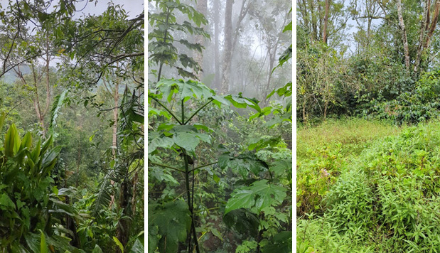
Agroforestry plot typology in the Tamblingan lands surrounding the Alas Mertajati. There is significant variation in the types of plants in agroforestry plots as well as in the intensity of intervention into the landscape. Field data collected in January 2023. Left: Low-level intervention on a semi-wild site on a steep hill with sugarplum, banana, coffee, taro, clove, and jackfruit. Middle: Mid-level intervention with coffee, banana, mandarin, and avocado. Right: Mid to high-level intervention with coffee, banana, flowers, and clove.